Mapping and surface modeling software
In the complicated game of petroleum exploration and production, the stakes are high, and great maps are vital to the decision-making process.
Petrosys software gives you the power to create extraordinarily precise and meaningful maps by providing a unique combination of quality output, comprehensive mapping, 3D visualization and surface modeling calculations so that you can effectively integrate data from the entire realm of seismic, well, engineering and economic systems involved in oil and gas exploration.
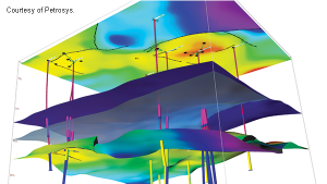
Because a three dimensional view provides a better understanding of subsurface structures, Petrosys’ 3d-viz option extends the display capabilities for EP information into the third dimensions of depth and time.
Based on Open Inventor, Petrosys’ 3d-viz allows the user to work confidently with a complex collection of surfaces, and to produce maps of extraordinary precision and detail.
The Petrosys development team chooses Open Inventor because of it’s unrivalled 3D graphics capabilities, easy integration into its development process and support of Windows and Linux desktop environments.