FracSIS software for exploration and mining
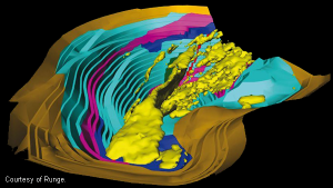
RungePincockMinarco’s FracSIS software system, powered by Open Inventor, is a spatial database and 3D visualization package for the exploration and mining industry. It is an essential tool for exploration managers and geologists helping them to make better informed decisions about their daily operations.
FracSIS combines a powerful object-oriented database specifically designed to store geological, geochemical and geophysical data with an interactive 3D visualization environment. The benefits of FracSIS’s data integration are visible to the entire organization, from management to geologists and clients. Because the databases store both geological models and non-geological files, such as Microsoft® Word®, PowerPoint®, Excel® and Adobe® PDF documents, it makes it a perfect vehicle for project management, collaboration and data distribution.
FracSIS also includes a comprehensive global coordinate system knowledge base, which the users can manipulate. For example, they can assign relevant coordinate system information to their data sets. This means that data stored in disparate coordinate systems can be viewed in a common coordinate system and be re-projected immediately into an entirely new coordinate system without duplicating and transforming data. Interpretations and data are constantly changing due to the nature of the exploration and mining industry. Ensuring that data is up-to-date and accurate across multiple applications is
therefore a constant challenge. To alleviate this, in FracSIS changes are made in the central database so everyone has access to the latest data.